Bradly Couch
Where do you live: United States.
Describe your art in three words: Art Based Research.
Your discipline: Conceptual Cartography.
Website | Instagram
What initially drew you to explore satellite imagery, and how did this evolve into your artistic practice?
I have a love for castles, palaces, and chateaux. I enjoy spending time viewing satellite imagery of their formal gardens. I’m fascinated by their beautiful and ornate designs. One day, I noticed what looked like a beautiful flower. I decided to shade it pink using Google’s polygon tool that allows users to draw shapes on a map. Little did I know that seeing that flower would cause pareidolia to bloom inside of me. Since then, I’ve locked myself away from the outside world to work on a project about the outside world—a project inspired by landscape, influenced by ancient myths, and driven by pareidolia.
 Bradly Couch | Jonah and Whale
Could you elaborate on the process of uncovering ancient myths in the Earth’s topography?
I scan the satellite imagery looking for features of Earth’s surface that resemble a character of a myth. Once found, I quickly draw a simple polygon to shade that area so it doesn’t become lost in the randomness. This first polygon is always like coloring outside the lines in a coloring book and needs a lot of refining (that’s why some things look so elementary). Eventually, enough objects become shaded where I’m able to visually tell the whole story in a confined geographic area. This is a key point of my work. I’m finding these stories full of quirky details in their entirety, in close proximity, and in the same logical order defined by ancient narratives.
How do you choose the locations or areas of the Earth to focus on in your work?
Ancient myths are very bizarre stories. The characters in these myths tend to have distinctive and often exaggerated traits. They’re often interconnected and have overlapping storylines. Characters from one myth might appear in another, or a recurring theme might be in multiple stories. These are like clues to what I should expect to find in close proximity when working with any given character. It’s important for readers to know that I don’t just add stuff to my map so it looks correct. I strictly adhere to following natural features within the landscape, which defines who, what, and where I draw.
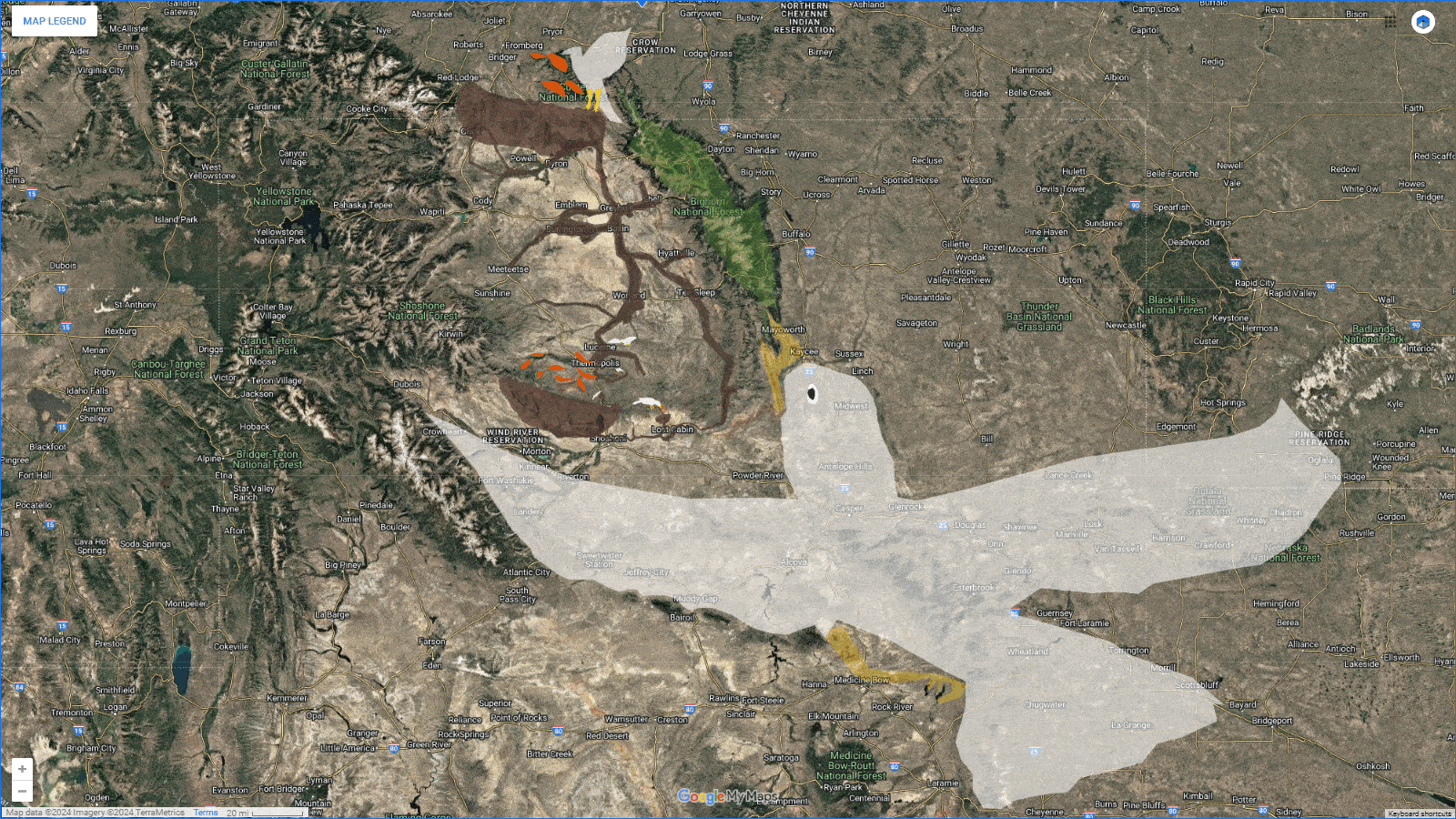 Bradly Couch | Birds Have Nests
Your work involves both ancient civilizations and contemporary audiences—how do you bridge these two worlds in your art?
I hypothesize that a civilization far more advanced than we are today must have been sent back to the Stone Age by a massive flood. The survivors knew it would take a very long time for humanity to get back to their level of sophistication and technical ability. Their time of remembrance was finite because, after a few generations of cavemen, their existence would surely be forgotten. It is my belief that those survivors created these fanciful stories based on their knowledge of Earth as seen from the heavens. They did this to ensure that only space-going people could solve their puzzle because only space travelers would be advanced enough to comprehend their advanced civilization. That was their only hope of being brought back into the human narrative, and my work is the bridge that connects their world to ours.
What is your methodology when interpreting topographical features as mythological figures or symbols?
I was born in a small town and raised in a Southern Baptist home. My view of the world was naive and narrow-minded, especially when it came to other religions and their beliefs. Because of this, I always have a supporting video, informative web page, or related images pulled up on my second monitor while I am working.
 Bradly Couch | Foxes Have Holes
Can you explain how satellite technology has transformed the way you view and interpret Earth’s surface?
Remote sensing technology, satellite imagery, and digital maps give us “angelic” vision, an artificial sixth sense with a heavenly view that we can employ to better perceive our world. You wouldn’t be interviewing me if they didn’t exist; they are crucial to my work. I hope one day to ride on Virgin Galactic to see with my own eyes the things that I’ve been able to discover through satellites. That would be a beautiful thing and is high on my bucket list.
What has been the most surprising discovery you’ve made while exploring satellite imagery for your artwork?
Hands down, I still get chills thinking about it. My most surprising moment was when I compared the face of my Jonah with that of Michelangelo’s. I split the two images in half and lined them up beside one another. I was blown away by the result. It appeared that the face of Michelangelo’s Jonah was superimposed over my map. Whenever Michelangelo changed his paintbrush to apply a different hue in his work, it matched exactly the color and hue of my map. Wherever the mountains created a unique texture on my map, Michelangelo chose to place an identical texture on his ceiling fresco in the Sistine Chapel. It’s so crazy to me.
Leave a Reply
You must be logged in to post a comment.